|
| |
 Five Ashes in East Sussex lies about 5 miles south west of Mayfield
on the A267.
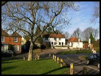
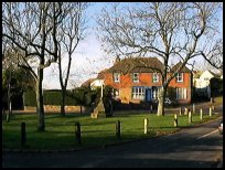
The local pub, called the Five Ashes,
what else, stands opposite the five ash trees from
which the village takes its name. The old building
was once a farmhouse, and the great-grandson of the
owner, Alfred Berwick, was the licensee from 1914 until
1959 when he retired. His daughter Rosie then took over. Five Ashes in East Sussex lies about 5 miles south west of Mayfield
on the A267.
The local pub, called the Five Ashes,
what else, stands opposite the five ash trees from
which the village takes its name. The old building
was once a farmhouse, and the great-grandson of the
owner, Alfred Berwick, was the licensee from 1914 until
1959 when he retired. His daughter Rosie then took over.
The long family association ended in 1977 when she and
her husband retired to Crowborough .
The Eastwood family were key figures in giving Five Ashes
its communal buildings. Boaz Eastwood helped erect an
old army hut from Eastbourne which served as the village
church, and his son Roy, was a leading-light in the fund
raising to build the village-hall in 1976.
'Twitts Gill' was once the home of Sir Austen Chamberlain,
son of the great Joseph Chamberlain, who in 1903 was
the Chancellor of the Exchequer, and Foreign Secretary
in the 1920's. He came to Five Ashes to escape the
cares of Parliament, and to expand his vast collection
of rock plants from all over the world. He was said to
have had 'green fingers' but lazy feet, as he was only
once seen walking the half mile to Five Ashes and back. |
|
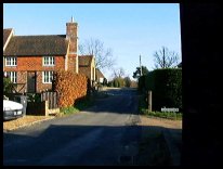 The nicest views in the area are coming into the
village from Heathfield, looking right towards
Mayfield.
A second viewpoint is on the corner
just as you leave the village on the way to
Mayfield, again to the right. The nicest views in the area are coming into the
village from Heathfield, looking right towards
Mayfield.
A second viewpoint is on the corner
just as you leave the village on the way to
Mayfield, again to the right. |
|
 Five Ashes in East Sussex has limited services within the village. Five Ashes in East Sussex has limited services within the village.
The nearest town is Heathfield about 4 miles
South East, for further larger shopping centres,
Eastbourne lies about 14 miles south, and
Tunbridge Wells about 10 miles north.
Busses pass through the village, however the nearest
trains run from Wadhurst about 10 miles north east, or
Tunbridge Wells. |
|
| Five Ashes is shown as the red symbol on the map. |
|
|
Nearby Villages
(click on symbol to see the village page) |
| Village= | |
Town= | |
Recorded in Domesday= |  |
| |
|
|
Blackboys |
(Charcoal and Soot) | | 4.28 miles |
|
|
Broad Oak |
(Smallpox at the Academy) | | 3.42 miles |
|
|
Burwash Common |
(Roughest pub in the South East) | | 5.47 miles |
|
|
Burwash Weald |
(Roughest pub in the South East) | | 5.89 miles |
|
|
Buxted |
(The first Iron Cannon in England) | | 3.94 miles |
|
|
Cade Street |
(Jack Cade and the Kentish rebellion) | | 3.78 miles |
|
|
Cross in Hand |
(The Crusaders Assembly) | | 2.07 miles |
|
|
Crowborough |
(The home of Sir Arthur Conan Doyle) | | 4.66 miles |
|
|
Dallington |
(Custers Last Stand!) | | 7.18 miles |
|
|
Fairwarp |
(Charcoal and the Army) | | 5.69 miles |
|
|
Framfield |
(380 years without a church tower) | | 4.82 miles |
|
|
Hadlow Down |
(Wealden Cannons and Charcoal) | | 1.64 miles |
|
|
Heathfield |
(19th Century Natural Gas) | | 2.99 miles |
|
|
Maresfield |
(Soldiers and Iron) | | 5.80 miles |
|
|
Mark Cross |
(Policeman arrests eccentric landowner) | | 4.36 miles |
|
|
Mayfield |
(Saint Dunstan and the Devil) | | 2.23 miles |
|
|
Punnetts Town |
(The Windmill on the Hill) | | 5.31 miles |
|
|
Rotherfield |
(Source of the rivers Rother and Uck) | | 2.99 miles |
|
|
Uckfield |
(Traction Engine destroys bridge) | | 5.99 miles |
|
|
Waldron |
(Fullers Earth) | | 3.59 miles |
|
|


